

Hyderabad, one of India’s fastest-growing metropolitan cities, is poised for a major urban mobility upgrade with the launch of Hyderabad Metro Phase 2 Expansion. Building on the success of Hyderabad Metro Phase 1, the second phase is designed to expand connectivity to emerging growth corridors, decongest traffic, and reshape the city’s real estate market. This blog explores the expansion plan, corridors, route maps, timelines, and current status of Phase 2 Expansion of Hyderabad Metro.
View & Compare Property Rates in Hyderabad
Phase II-A Corridors of Hyderabad Metro Map
Corridor 1 of Hyderabad Metro Map: Nagole → RGIA Shamshabad Airport (Airport Corridor)
-
Type: Elevated + Underground
-
Length: 36.8 km
-
Highlights:
-
Provides direct airport connectivity, addressing long-pending demand.
-
Supports business travelers, IT workforce, and airport-driven commercial growth.
-
Strong real estate upside around Shamshabad and airport-adjacent townships.
Corridor 2 of Hyderabad Metro Map: Raidurg → Kokapet Neopolis
-
Type: Elevated
-
Length: 11.6 km
-
Highlights:
-
Enhances west connectivity.
-
Serves middle-class and working-class residential belts.
-
Supports high-density affordable housing clusters.
Corridor 3 of Hyderabad Metro Map: Miyapur → Patancheru Extension
-
Type: Elevated
-
Length: 13.4 km
-
Highlights:
-
Extends metro reach into Patancheru, a fast-growing industrial and residential hub.
-
Unlocks large land parcels for mixed-use development.
-
Boosts rental demand for IT and industrial workforce.
Corridor 4 of Hyderabad Metro Map: LB Nagar → Hayathnagar
-
Type: Elevated
-
Length: 5.5 km
-
Highlights:
-
Improves accessibility to eastern periphery.
-
Strong demand from healthcare and educational institutions.
-
Encourages mid-segment housing growth.
Corridor 5 of Hyderabad Metro Map: MGBS → Chandrayangutta (Old City Stretch)
-
Type: Elevated & Underground
-
Length: 7.5 km
-
Highlights:
-
Critical for inclusivity by connecting the Old City.
-
Improves mobility in high-density, culturally important zones.
-
Sensitive construction due to heritage and demographic factors.
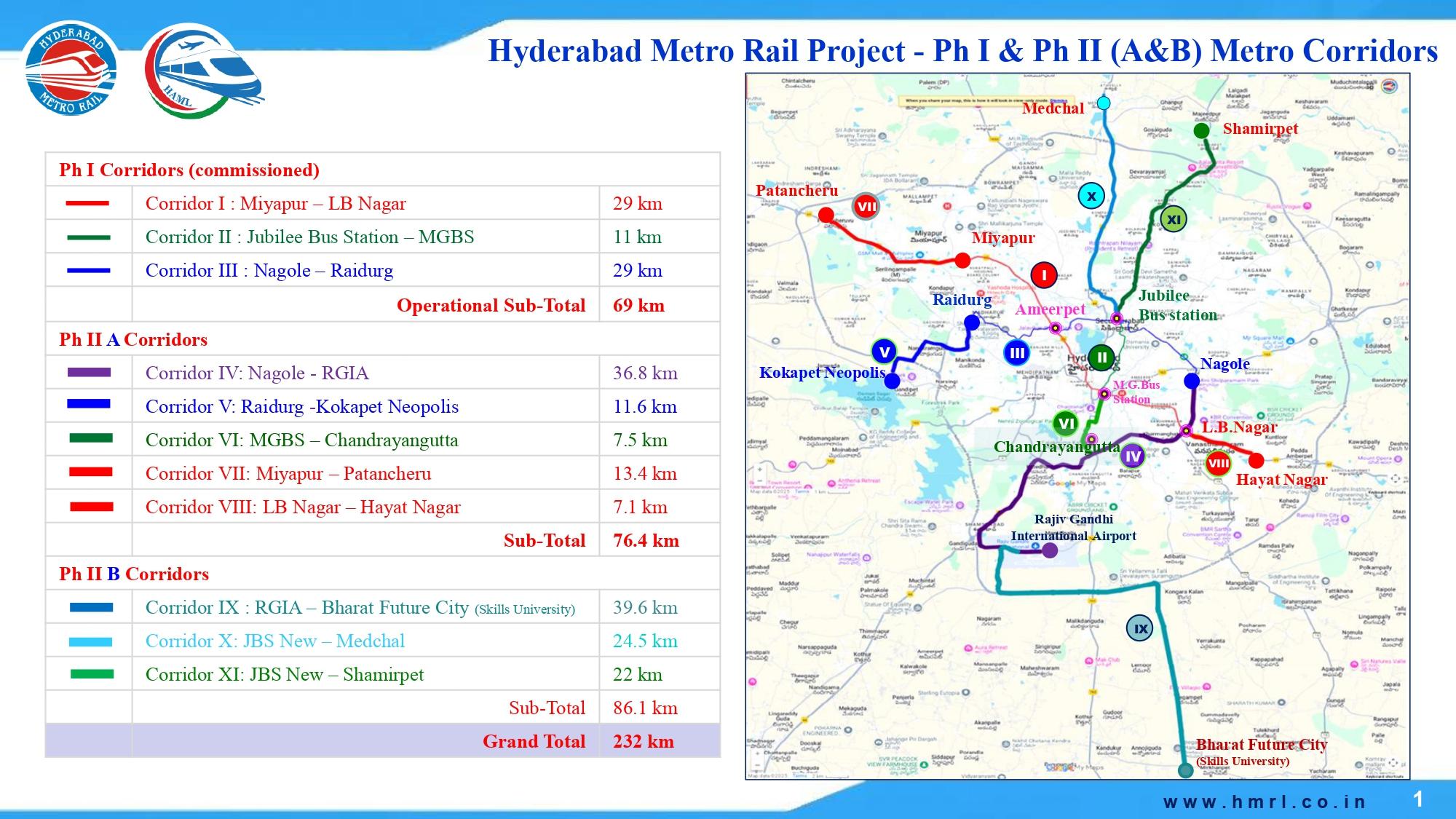
Phase II-B Corridors (86.1 km) of Hyderabad Metro Map
Corridor 1 of Hyderabad Metro Map: Shamshabad Airport → Future City
-
Type: Elevated & Underground (Hybrid)
-
Length: 39.6 km (21 km Elevated + 1.5 km Underground + 17 km At Grade)
-
Highlights:
-
Connects Hyderabad International Airport to Future City along the ORR.
-
Expected to catalyze real estate and IT/tech parks in the airport–ORR belt.
-
At-grade sections reduce costs and integrate with peripheral roads.
Corridor 2 of Hyderabad Metro Map: Jubilee Bus Station (JBS) → Medchal
-
Type: Elevated
-
Length: 24.5 km
-
Stations: 18
-
Highlights:
-
Connects North Hyderabad suburbs with central hubs.
-
Opens growth for affordable and mid-segment housing along Medchal Road.
-
Supports industrial and educational institutions in the northern belt.
Corridor 3 of Hyderabad Metro Map: Jubilee Bus Station (JBS) → Shamirpet
-
Type: Elevated & Underground (Hybrid)
-
Length: 22 km (20.35 km Elevated + 1.65 km Underground)
-
Stations: 14
-
Highlights:
-
Strengthens connectivity to Shamirpet, a biotech and pharma hub.
-
Spurs industrial corridor growth and professional housing demand.
-
Underground design minimizes disruption in dense areas.
Expected Metro Interchange Stations in Phase II
| Interchange Station | Connecting Corridor | Importance |
|---|---|---|
| MGBS | Existing Metro + Old City Corridor | Major interchange connecting Old City to existing metro network |
| Raidurg | Existing Blue Line + Neopolis Extension | Strengthens connectivity to Financial District and IT corridor |
| JBS (Jubilee Bus Station) | Medchal & Shamirpet Corridors | Key transport hub linking north suburbs with city center |
| Nagole | Existing Metro + Airport Corridor | Connects eastern Hyderabad to airport route |
| Shamshabad Airport | Airport Corridor + Future City Corridor | Major international travel hub |
Timeline & Approvals of Hyderabad Metro Map Expansion
-
2022–2023: Conceptualisation and initial approvals with DPR submissions to the Central Government.
-
2024: Phase 2A approved by the Telangana Government and forwarded to the Centre.
-
2025–2026: Expected start of construction in priority corridors (Airport, Patancheru, Medchal).
-
2028–2030: Phased rollouts, with Airport Corridor targeted for early completion.
Latest News Timeline (Since 2024) of Hyderabad Metro Map Expansion
-
January 2024 — Telangana CM finalises 70‑km plan of Hyderabad Metro Map Phase 2
Chief Minister Revanth Reddy finalised a ~70 km expansion plan under Phase II, mapping out four new corridors to connect the airport from different parts of the city. This marked the first major push for Phase 2 after years of discussion. -
October 2024 — Hyderabad Metro Map Phase 2 works to be completed in four years
Reports confirmed that the 76.4 km expansion across five corridors would be executed within four years, with funding sourced from the state, central government, multilateral loans, and PPP arrangements. -
November 2024 — Govt sanctions ₹24,269 crore for Hyderabad Metro Map Phase 2 Expansion
The Telangana government gave administrative sanction to Phase II with a budget of ₹24,269 crore. This included 76.4 km of new lines and a commitment to expand metro access to underserved zones. -
November 2024 — Works for Hyderabad Metro Map Phase 2 in Old City to begin from January
Authorities announced that construction in the Old City (MGBS to Chandrayangutta) would start in January 2025, involving property demolition, compensation, and geotechnical studies. -
November 2024 — Hyderabad Metro Map Expansion to add 76.4 km and 54 stations
Further details confirmed Phase II expansion would feature 76.4 km and 54 stations. Work on the Old City corridor was prioritized for early 2025. -
May 2025 — DPRs for Hyderabad Metro Map Phase 2‑B expansion approved
The Hyderabad Airport Metro Ltd (HAML) board approved detailed project reports for Phase II‑B, consolidating three corridors (JBS–Medchal, JBS–Shamirpet, and RGIA–Future City). Total cost was pegged at ~₹19,579 crore. -
June 2025 — Govt grants sanction for Hyderabad Metro Map Phase 2‑B Expansion
The Telangana government formally issued administrative sanction for Phase II‑B as a joint venture between the State and Centre, paving the way for tendering and financing discussions. -
June 2025 — State submits DPR for Hyderabad Metro Map Phase 2‑B Expansion
The government submitted the Phase II‑B DPR to the Centre, covering 86.1 km across three corridors at an estimated cost of ₹19,579 crore. -
July 2025 — Utility mapping begins for Old City corridor of Hyderabad Metro Map
HAML initiated utility surveys in the Old City stretch (Darulshifa to Chandrayangutta), mapping heritage structures and underground utilities before pillar works could begin. - August 2025 — Works advance in Old City for Hyderabad Metro Map despite fund crunch
Despite delays in central funding, demolition and groundwork for the Old City corridor (~7.5 km) continued. Over 300 property demolitions were reported, indicating visible on‑ground progress. -
February 2026 — Telangana Cabinet approved the acquisition of Metro Phase 1.
To facilitate a smoother Phase 2 rollout under a state–Centre joint model, the Telangana government has acquired the entire Metro Phase 1 for a significant strategic move to unlock funding.
Real Estate Impact
Hyderabad Metro Map Phase 2 is expected to reshape the city’s property market much like Hyderabad Metro Map Phase 1 did for areas such as Miyapur, Gachibowli, Uppal, and Kukatpally. Each corridor carries unique implications for residential, commercial, and mixed-use real estate development:
1. Airport Corridor of Hyderabad Metro Map (Raidurg → Shamshabad & Shamshabad → Future City)
-
Airport connectivity historically drives hospitality, commercial, and high-end residential growth.
-
Developers are already lining up gated communities, premium villas, and office parks along the Shamshabad–ORR stretch.
-
Future City is expected to be positioned as a smart city hub, which could anchor IT SEZs, data centers, and global business parks.
-
Rental demand from airline staff, business travelers, and airport-linked services will rise.
2. Patancheru Extension of Hyderabad Metro Map (Miyapur → Patancheru)
-
Patancheru has been evolving as a manufacturing and industrial hub; metro access will push demand for affordable and mid-income housing.
-
Expect mixed-use townships with schools, malls, and healthcare to flourish.
-
Industrial workforce housing and rental markets will gain traction, especially for blue- and white-collar employees.
3. LB Nagar & Hayathnagar Corridors of Hyderabad Metro Map
-
These corridors pass through densely populated residential belts with demand for affordable housing.
-
Developers will focus on 2 & 3 BHK apartments, plotted developments, and budget housing projects.
-
Hospitals, colleges, and coaching centers in this belt will see improved access, boosting land values.
4. Old City Stretch of Hyderabad Metro Map (Darulshifa → Chandrayangutta)
-
A transformational corridor for the Old City, historically under-served by metro infrastructure.
-
Can unlock redevelopment potential for heritage-adjacent properties while also attracting retail and small-scale businesses.
-
Challenges remain around land acquisition, but success here could stabilize real estate prices and attract community-focused housing projects.
5. Medchal & Shamirpet Corridors of Hyderabad Metro Map (JBS → Medchal/Shamirpet)
-
North Hyderabad has remained relatively affordable compared to the west; these corridors can rebalance growth.
-
Medchal Road will benefit from affordable apartment complexes, logistics hubs, and education-linked housing.
-
Shamirpet, with its biotech and pharma ecosystem, will attract research parks, student housing, and professional rental demand.
-
Institutional land buyers (universities, biotech firms, hospitals) may enter aggressively.
6. Airport–ORR Belt of Hyderabad Metro Map (Future City)
-
The large land banks along the ORR are expected to witness integrated township launches.
-
Metro access combined with expressways will make it a preferred hub for tech parks, logistics hubs, and large-scale residential projects.
-
Could emerge as the next Gachibowli in terms of scale and global investments
Challenges of Hyderabad Metro Map Expansion
-
Funding & Execution: Cost escalations and land acquisition hurdles.
-
Heritage & Old City Concerns: Community sensitivity and infrastructure constraints.
-
Integration with ORR & Future City: Long-term urban planning coordination needed.
Conclusion
Hyderabad Metro Map Phase 2 Expansion is not just a transport upgrade; it is a city-shaping infrastructure project. With over 100 km of new corridors, it will expand economic activity, boost real estate, and enhance liveability. While challenges remain, the government’s push for airport and peripheral connectivity signals a transformational decade ahead for Hyderabad.
For property buyers and investors, the Hyderabad Metro Phase 2 route expansion could play a key role in shaping long-term real estate demand.
Discover Top Projects & Best Deals in Hyderabad
Note: This article was prepared with the assistance of AssetScan AI. While every effort has been made to ensure accuracy, readers are advised to verify details independently before making any decisions.
